FRANKLIN, BENJAMIN,SAMUEL,GARRICK (2013) Characterising fracture systems within upfaulted basement highs in the Hebridean Islands: an onshore analogue for the Clair Field. Doctoral thesis, Durham University.
![[img]](/style/images/fileicons/application_pdf.png)
| PDF - Accepted Version 60Mb | |
![[img]](/style/images/fileicons/application_msword.png) | Microsoft Word - Supplemental Material 25Mb | |
| Microsoft Word - Supplemental Material 40Mb | |
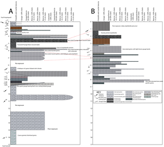
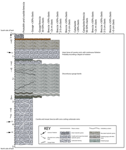
![[img]](http://etheses.dur.ac.uk/7765/5/Figure_4.33_-_structural_log_at_Seaforth_Valley.jpg?DDD15+)
| Image (JPEG) 7Mb | |
![[img]](http://etheses.dur.ac.uk/7765/6/Figure_4.48_-_structural_log_at_Orasaigh.jpg?DDD15+)
| Image (JPEG) - Supplemental Material 2067Kb |
Abstract
The Outer Hebrides are a structurally complex area, comprised predominantly of crystalline basement rocks of the Lewisian Gneiss Complex with the multiply reactivated Outer Hebrides Fault Zone following eastern portions of the islands for over 200 km along strike. In Eastern Lewis, the Permo-Triassic Stornoway Formation unconformably overlies Lewisian basement rocks of the OHFZ in a half-graben. This structural setting is analogous to the major offshore Clair oil field, where oil is found within Devonian-Carboniferous red beds of the Clair Group directly overlying Lewisian Gneiss Complex rocks of the Rona Ridge, which was upfaulted in the Mesozoic. Oil connection and flow has been proven in the basement rocks at Clair, however, little is known about the nature of fracturing and faulting within the basement and how these faults link to the cover sequence. Here, the cover and basement rocks of the Outer Hebridean Islands of Lewis and Harris are studied as an analogue.
Faults, fault rocks and deformation are characterised within the Stornoway Formation, and at the basement-cover interface, allowing recognition of Mesozoic and younger faults within the Lewisian and their separation from older structures. Three fault sets are distinguished within the Stornoway Formation: a NNW-SSE striking normal fault set (Set 1); a N-S and E-W quadrimodal normal fault set (Set 2); and a less numerous late E-W strike-slip set (Set 3). Tertiary dolerite dyke intrusion occurred along Set 1 and Set 2 faults prior to the formation of Set 3. Palaeostress analyses reveal that Set 1 and 2 result from E-W and ENE-WSW directed extension vectors, followed by E-W directed contraction associated with Set 3. These orientations are interpreted to be representative of Mesozoic extension related to the opening of the Atlantic, followed by Cenozoic contraction. Faults in the Stornoway Formation are accompanied by development of authigenic clay-bearing gouges and cataclasites, ± calcite cement and late zeolite. Zeolite is often associated with secondary porosity, produced through dissolution of calcite. Mesozoic and younger faults are readily identified in Lewisian Gneiss rocks of the Stornoway region based on fault rock characterisation, and these faults also display an ENE-WSW directed extension vector. The major bounding faults of the Stornoway Formation are sub-parallel with the local foliation and the reactivation of the basement foliation by Mesozoic faults is proven. Fault trends identified within the Stornoway Formation are also sub-parallel with the local foliation. Conjugate faulting apparent in the Stornoway Formation is not present within the Lewisian, possibly indicating a degree of structural detachment between faulting in the basement and faulting in the cover, probably linked to the development of low-angle faults within the Stornoway Formation within metres of and parallel with the basement-cover unconformity. The basement-cover interface displays abundant evidence of fluid overpressure, potentially linked with dewatering during lithification and local fault movements.
Mesozoic and younger-age brittle fault rocks post-date pre-existing extensive ductile and brittle deformation that are most intense within the OHFZ. Brittle fault rocks of pre-Mesozoic age are associated with pseudotachylites, fine grained cataclasites, epidote-bearing cataclasites and pumpellyite-bearing cataclasites. Mesozoic fault rocks contain authigenic clay-bearing gouges and cataclasites often associated with zeolite and adularia mineralisation that often accompanies the development of secondary porosity within the fault rocks. This chronological fault rock assemblage represents the continued exhumation of the islands after the successively lower temperature and pressures conditions experienced since the initial development of the basement gneiss complex. Across Lewis, fault rock characterisation allows identification of major Mesozoic and younger structures that cross the islands, with a km-scale offset postulated across the major Seaforth Fault that may link the major NE-SW striking Minch Fault to a NE-SW striking fault lying offshore western Lewis/Harris. On Lewis, the predominant orientation of Mesozoic structures is NNW-SSE, becoming NW-SE on Harris, south of the Seaforth Fault and where foliation becomes pervasively NW-SE. It seems highly likely that, as identified in the Stornoway Region, the foliation orientation plays a significant role in the development of later structures.
At Clair, fault rock development within the Devonian-Carboniferous Clair Group is dependent on the host lithology, with gouges formed in mudstones, and granulation seams found in porous, oil-bearing sandstones. Calcite-cemented breccias are present in zones of calcite cemented host rock. Pyrite and calcite vein mineralisation are associated with oil influx, and a late phase of dissolution was accompanied by faulting that produced uncemented brittle fault rocks (gouge). In the basement, oil is seen along open fractures and in vug-like secondary porosity associated with adularia mineralisation, of which two forms are present. Euhedral adularia is often altered to green clay and partially to wholly infills tensile fractures that may predate the emplacement of the Clair Group. Later adularia occurs as ‘speckled’ veins, with haematite, clay, calcite, pyrite, minor zeolite and oil, and appears to be contemporaneous with calcite-pyrite veining (i.e. Mesozoic in age). Porosity in both adularia-bearing fractures is associated with oil staining. The basement displays little evidence of extensive mylonites or phyllonites that are obvious in the OHFZ of the Outer Hebrides.
Scalability studies show that it is difficult to assign power-law spacing distributions to fractures within the basement rocks of the Hebrides. Fractures parallel with Mesozoic structures do however tend to display a greater degree of organisation with more clustering of fractures as the faults are approached. Mesozoic fault-perpendicular fracture sets display more strongly random fracture spacing distributions consistent with a jointing origin. At Clair, fracture spacing studies in the cover show a low fracture density compared to basement, with fracture spacing that is clustered and may be well represented by power-laws. Dissolution has locally produced a randomly spaced fracture network. Although fracture spacings in the Hebridean Lewisian are generally random, fracture apertures define a clear power law relationship over ~5 orders of magnitude. Similarly, results from the Clair group also display equivalent power law relationships.
| Item Type: | Thesis (Doctoral) |
|---|---|
| Award: | Doctor of Philosophy |
| Keywords: | Lewisian Gneiss Complex, Basement-cover interface, Fractured basement characteristics, Quantitative fracture attributes, Fault rock evolution, Fault rock characteristics, Clair Field fracture attributes, Mesozoic faulting on the UK Atlantic margin |
| Faculty and Department: | Faculty of Science > Earth Sciences, Department of |
| Thesis Date: | 2013 |
| Copyright: | Copyright of this thesis is held by the author |
| Deposited On: | 30 Aug 2013 11:18 |
Social bookmarking: 


![]()
![]()

